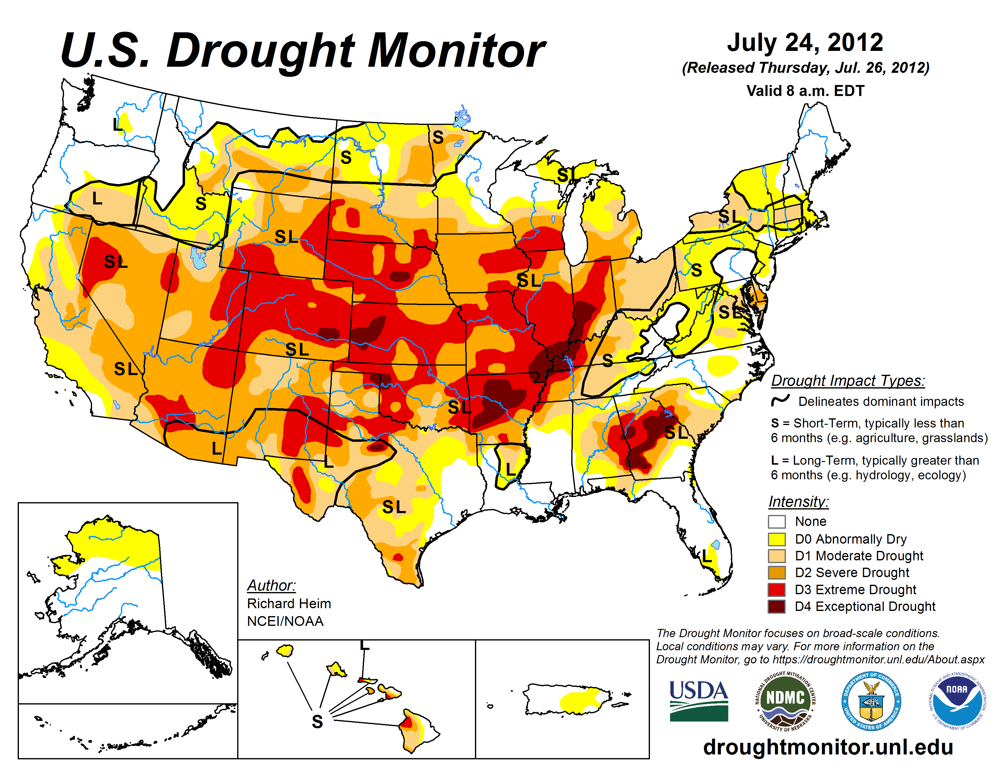
The July 24 U.S. Drought Monitor showed widespread intensification of drought through the middle of the country, according to the National Drought Mitigation Center at the University of Nebraska-Lincoln. The map also set a record for the fourth straight week for the area in moderate drought or worse in the 12-year history of the U.S. Drought Monitor.
The July 24 map put 53.44 percent of the United States and Puerto Rico in moderate drought or worse, up from 53.17 percent the week before; 38.11 percent in severe drought or worse, compared with 35.32 a week earlier; 17.2 percent in extreme drought or worse, compared with 11.32 percent the week before; and 1.99 percent in exceptional drought, up from .83 percent the preceding week.
“We’ve seen tremendous intensification of drought through Illinois, Iowa, Missouri, Indiana, Arkansas, Kansas and Nebraska, and into part of Wyoming and South Dakota in the last week,” said Brian Fuchs, a climatologist and U.S. Drought Monitor author. “The amount of D3 developing in the country has increased quite a bit for each of the last several weeks.”
Fuchs said that the 48 contiguous states had a 7.04 percent increase in extreme and exceptional conditions, which was the largest single increase since a 5.04 percent jump in May 2002.
Fuchs also noted that as of the July 24 U.S. Drought Monitor, every state in the country had at least a small area shown as abnormally dry or worse. “It’s such a broad footprint,” he said.
“This drought is two-pronged,” Fuchs said. “Not only the dryness but the heat is playing a big and important role. Even areas that have picked up rain are still suffering because of the heat.”
The forecast for most of the drought-affected area is for drought to continue to develop and intensify. “Conditions are likely to persist,” Fuchs said. “We’ll see further development and intensification into the fall.” Fuchs based his assessment on the Seasonal Drought Outlook released July 19.
The U.S. Drought Monitor map is jointly produced by the National Drought Mitigation Center at the University of Nebraska-Lincoln, the National Oceanic and Atmospheric Administration, the U.S. Department of Agriculture, and about 350 drought observers across the country. It is released each Thursday based on data through the previous Tuesday.
Drought Monitor authors synthesize many drought indicators into a single map that identifies areas of the country that are abnormally dry (D0), in moderate drought (D1), in severe drought (D2), extreme drought (D3) and exceptional drought (D4).
Statistics for the percent area in each category of drought are automatically added to the U.S. Drought Monitor website each week for the entire country and Puerto Rico, for the 48 contiguous states, for each climate region, and for individual states: http://drought.unl.edu/MonitoringTools/USDroughtMonitor/DroughtMonitorTips.aspx
The National Climatic Data Center maintains drought data based on the Palmer Drought Severity Index, calculated to the beginning of the historic record: http://www1.ncdc.noaa.gov/pub/data/cmb/sotc/drought/2012/06/uspctarea-wetdry-mod.txt
U.S. Drought Monitor: http://droughtmonitor.unl.edu
Seasonal Drought Outlook: http://www.cpc.ncep.noaa.gov/products/expert_assessment/seasonal_drought.html
-- Kelly Helm Smith, National Drought Mitigation Center